Omega Block Dominates U.S. Weather: What Lies Ahead for Conditions?
The weather pattern known as an omega block is currently disrupting typical jet stream flows across the United States, resulting in varied weather conditions that may persist until at least next weekend. While some areas will experience cooler, showery weather, others will remain mild and dry. Potential changes could emerge late this week, but no definitive switch to a zonal flow is expected soon.
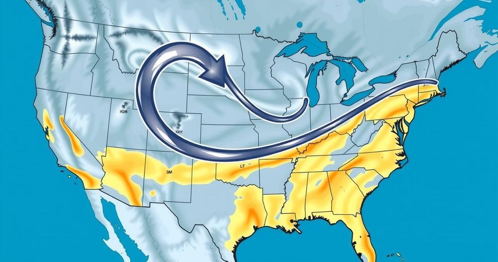
For the foreseeable future, an omega block is firmly in control of weather patterns across the United States, disrupting the usual west-to-east jet stream flow. This blockage results in stagnant and varied weather, featuring cooler and showery conditions in the East and West, contrasted by milder, clearer skies in the north-central regions. Concern is growing that this weather pattern might persist for quite a while, possibly extending through next weekend, according to expert predictions.
Meteorologists have identified this phenomenon as an omega block, notably because of its resemblance to the Greek letter omega (Ω). Jonathan Erdman, a meteorologist at Weather.com, describes the pattern as a barrier akin to a large rock nestled in a stream, blocking the normal flow of the jet stream. This alteration in dynamics leads to unusual patterns of weather across the country, especially during months like April and May.
Brian Hurley, a meteorologist with the Weather Prediction Center, elaborated that this blocking configuration is common when upper-level low-pressure systems become isolated from the prevailing air currents. This scenario often leads to extended periods of unstable and chilly weather in specific areas, while others may experience uncharacteristically dry and warm conditions for extended stretches of time.
Current conditions present a blend of cool, showery weather in some parts of the East and West, while the north-central U.S. enjoys mostly mild and clear skies. The Weather Prediction Center confirmed that a persistent blocking pattern currently impacts the Lower 48 states, largely influenced by a slow-moving upper low situated over the Ohio Valley, another slow mover over the Southwest, and an area of high pressure improvising fair weather in the northern Plains and Upper Midwest.
Temperature variances in the affected regions may remain pronounced, oscillating between well below normal and above normal figures this week as the omega block continues its reign. Hurley noted that a potential breakdown may arise around mid- to late week, before the established pattern kicks back into gear by the following weekend.
Looking ahead, Hurley expressed cautious optimism about temporary shifts, stating, “By late week into early next week, we could be looking at a closed upper low in the Mississippi Valley and another one in the West Coast.” However, despite visibilities of a slight change, he cautioned that the required zonal flow of air—which facilitates swift west-to-east weather systems—remains absent for now. The outlook for the immediate future suggests that, unless significant shifts occur, current weather conditions may linger longer than desired.
In summary, the omega block currently dominating U.S. weather is expected to persist, causing disruptions in the usual jet stream flow. With forecasts predicting a continuation of this pattern at least until next weekend, regions can expect contrasts of cool, unsettled weather alongside dry, warmer spells. Meteorologists indicate that while temporary changes might occur late this week, a substantial shift to a zonal flow is not on the horizon, which keeps the current weather entrenched.
Original Source: www.usatoday.com


